 Maine Genealogy
 Support Maine Genealogy by
  Search the Census
Browse the Census
Hopkins Academy Grant Near Grand Falls West Branch
Jarvis Gore, East of Eddington [later Clifton]
Lower East Indian Township No. 1
Lower East Indian Township No. 1 [later Passadumkeag]
Lower West Indian Township No. 2 [later Woodville]
No. 1, 3rd Range West of the East Line of the State [later Reed Plantation]
No. 1, Range 5 West of the East Line of the State [T1 R5 WELS]
No. 10, Range 5 West of the East Line of the State [later Masardis]
No. 11, Range 5 West of the East Line of the State [later Ashland]
No. 12, Range 3 West of the East Line of the State [later Mapleton]
No. 13, Range 3 West of the East Line of the State [later Washburn]
No. 2, [3rd] Range West of the East Line of the State [later Glenwood Plantation]
No. 2, Range 5 West of the East Line of the State [later Benedicta and Silver Ridge Townships]
No. 3 First Range [T3 R1 NBPP]
No. 3, Range 5 West of the East Line of the State [later Sherman]
No. 3, Range 7 West of the East Line of the State [T3 R7 WELS]
No. 4 First Range [later Lakeville]
No. 4, Range 6 West of the East Line of the State [later Patten]
No. 5, Range 3 West of the East Line of the State [later Oakfield]
No. 5, Range 6 West of the East Line of the State [later Mount Chase]
No. 7, 4th Range [later Drew Plantation]
No. 7, Range 5 West of the East Line of the State [T7 R5 WELS]
River Township No. 4 Third Range [later Winn]
Township Letter A, 6th Range [later Medway]
Township Letter A, 7th Range [later partly incorporated as East Millinocket]
Township No. 4, Range 6 West of the East Line of the State [later Patten]
Township No. 6, Range 3 West of the East Line of the State [later Smyrna]
Township Not Stated [evidently T1 R4 WELS, later part of Molunkus Plantation]
Township Not Stated [evidently T3 R8 NWP, later Seboeis Plantation]
Township Not Stated [evidently T7 R8 NWP, later Bowerbank]
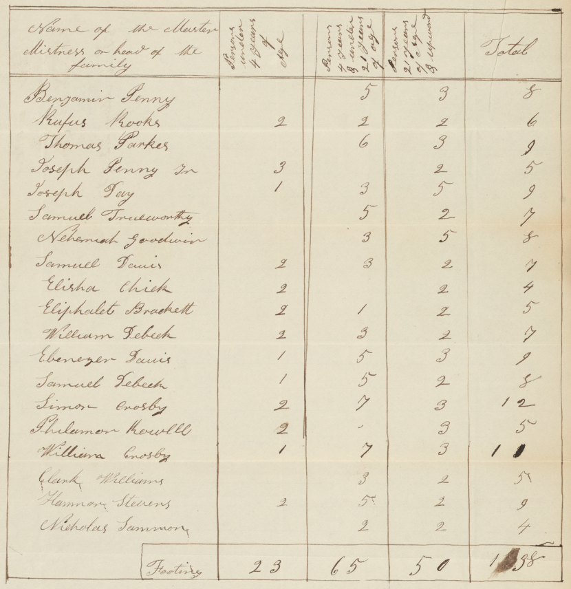 In 1837 Maine accepted its portion of a federal budget surplus, to be distributed to the towns in proportion to their population. Selectmen of the various towns were authorized to conduct censuses of all inhabitants, excepting "foreigners not naturalized, whose residence has not been established at least four years in any of the cities, towns or plantations, or any other place wherein such enumeration is to be made—and Indians not taxed." The census schedules were to list heads of households, and to "distinguish all persons under the age of four years; those of four and under twenty-one; and those of twenty-one and upwards, belonging to each city, town and plantation in this State, on the first day of March, eighteen hundred and thirty-seven."
The schedules of Bangor, Portland, Dennysville, and dozens of unincorporated townships and plantations have survived, and are indexed in this database. Names are linked to images of the original census schedules, either at FamilySearch (free registration required) or Digital Maine.
A transcription of the census schedule from Eliot will be found in the research library of the Maine Historical Society. Transcriptions of a few additional schedules may be found online:
Source: Maine Surplus Revenue Census, 1837, Maine State Archives, provided online by Digital Maine and FamilySearch.